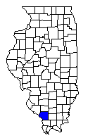
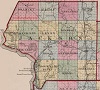
Jackson county is situated in the southeastern section of the state. It is
bounded north by Randolph county, east by Franklin, south by Union, and west by
Randolph and the Mississippi river. Its length is 30 miles, with a medium width
of 24; its area is 720 square miles.
This county is watered by Muddy
river and its tributaries. - It is generally timbered land, although it contains
many prairies. That part of the Mississippi which forms its western boundary,
is, with few exceptions, high and rocky. Six or seven miles above the mouth of
Muddy river, a chain of rocks extend across the Mississippi, and forms its bed
and from the height of the banks on each side, and the immense masses of rock
which are still to be seen rising from them, we are irresistibly led to
conclude, that here was once a complete barrier to the passage of the water from
the north. But as it is not our present intention to indulge in geological
speculations, we shall only speak of things as they are. The Grand Tower, which
is a perpendicular rock rising from the river at this place, is at present about
70 or 80 feet in height, but has the appearance of having been worn down. It
consists of horizontal strata of sand stone, and corresponds in its appearance
and its stratifications, with the banks of the Mississippi. The high bank which
commences here, continues with little interruption to the mouth of the Kaskaskia
river; sometimes presenting a bare perpendicular rock, with those numerous
excavations and fanciful appearances, to which the boatmen have given the names
of the 'Devil's tea table,' 'bake oven,' 'back bone,' &c.; at others, gently or
abruptly sloping, covered with a light soil, and a scanty growth of cedars.
Muddy river, which meanders through the interior of this county, is
navigable for a considerable distance, and affords to the inhabitants every
facility for exporting their surplus produce. On this stream, near Brownsville,
there is a saline, which has been leased for 10 years. It is not so extensive as
the Ohio Saline, but is sufficiently so to supply this and the adjoining
counties. A large body of good stone coal is also said to exist about 25 miles
up this stream, from which the smith's in the vicinity receive their supplies,
and some is even taken to New Orleans. Native copper, similar to that found on
the Illinois near Peoria, has also been found on the banks of Muddy river. It
appears, however, merely in the form of detached masses lying on the surface,
and affords no evidence of the existence of that mineral in any quantity in the
vicinity. On the margin of this stream are several beautiful prairies, which are
very fertile and quite thickly settled.
Jackson county contains 1549
inhabitants, it is attached to the third judicial circuit; sends one member to
the house of representatives, and one to the senate. Its seat of justice is
Brownsville.
Big Beaucoup creek, rises in the southeastern part of
Washington county, and running a southwardly course through Randolph and
Jackson counties, about 40 miles, falls into Big Muddy river, in section 35,
of township 7 south, in range 2, west of the third principal meridian. A
toll bridge has lately been built across this stream, where the state road
leading from Shawneetown to Kaskaskia crosses it.
Big Muddy
river, (Riviere au Vase, ou Vaseux, discovered and named by the
French,) a considerable stream in the southwestern part of the state. It
rises between the waters of the Kaskaskia and Little Wabash, and running a
southern and southwestern course through the counties of Jefferson,
Franklin, Jackson and Union, empties into the Mississippi, between sections
1 and 12, of township 11 south, in range 4, west of the 3d principal
meridian, about 50 miles above the mouth of the Ohio. Being fed by Little
Muddy river, Beacoup[sic] creek, and several other smaller streams, it is
rendered boatable for 40 or 50 miles through a fine prairie country. About
25 miles from its mouth, stone coal of a good quality, is found in a
sufficient quantity to supply the surrounding country, and afford a surplus
for exportation. Native copper has also been found in detached masses on the
banks of this stream.
Brownsville, a flourishing
post town, and the seat of justice of Jackson county, incorporated in 1819,
under the direction of five trustees. It is situated on Big Muddy river, on
section 2, of township 9 south, in range 3, west of the third principal
meridian. The inhabitants are principally German. About 4 miles above this
place, on the east bank of Muddy, is a saline building stone of the best
quality also exists in abundance. Brownsville is in latitude 37 degrees 45'
north, 84 miles, somewhat west of south, from Vandalia.
Cedar
creek, a small stream of Jackson and Union counties. It runs a
northwest course, and empties into Big Muddy river, in section 11, of
township 10 south, in range 3, west of the third principal meridian.
Colombo creek, runs a southeast course through the
northwestern part of Jackson county, and empties into Big Beaucoup creek.
Little Beaucoup creek, a small branch of Big Beaucoup,
running through Randolph and Jackson counties.
Muddy saline,
situated on the Muddy river near Brownsville, the county seat of Jackson. It
is owned, and has been leased by the state to different individuals.
Ovid, a town in Jackson county, laid out in 1820. It is
situated eight miles east of the Mississippi river, near the line which
divides Jackson and Union counties. The main road leading from America and
Golconda through Jonesborough and Brownsville, to Kaskaskia and St. Louis,
passes through this place. It is 15 miles south of Brownsville, and about
the same distance nearly north of Jonesborough. The lands in the vicinity,
are of a very good quality, and mill seats are numerous within a few miles
of the place.
Extracted from A Gazetteer of the States of Illinois and Missouri, author Lewis C. Beck, published in 1823.
Randolph |
Perry | Franklin |
Perry MO |
 |
Williamson |
| Union |